Privacy and Cookie policy information available at https://uip.primavera-h2020.eu/privacy.
Disclaimer: The data presented in the Data Viewer serves to illustrate some of the results produced in the PRIMAVERA project.The data producers and data providers make no warranty, either express or implied, including, but not limited to, warranties of merchantability and fitness for a particular purpose. By using the Data Viewer, you accept the terms of this disclaimer. Please get in touch with the project should you need more information (primavera_inquiries@bsc.es).
About Data Viewer
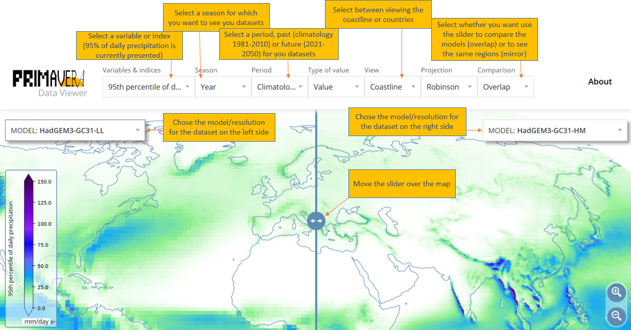
The PRIMAVERA Data Viewer is a visual prototype that explores some of the PRIMAVERA project results obtained from different Global Climate Models (read more about the climate models used in PRIMAVERA here). The aim of the prototype is to illustrate the climate model results obtained from different models and resolutions. We selected a few well known climate indices to illustrate the data. At the moment, the Data Viewer provides results from the past model runs (i.e. climatology) as well as the early project results from the future model runs. You can read more about the climate model simulations conducted in PRIMAVERA here.
Although the project uses the latest generation of advanced high-resolution global climate models, these models (like all models) are not perfect. In addition, we only present some of the obtained results, without providing detailed evaluation or comparison of the results obtained from different models. Consequently, the Data Viewer has only an illustrative purpose to visually suggest what we can expect from high resolution global climate models. The results from climate models demand careful analysis and consideration of uncertainties, before this data can meaningfully inform decisions.
FAQs
-
How to use PRIMAVERA Data Viewer

-
What are PRIMAVERA simulations and experiment design?
The main PRIMAVERA simulations are conducted following the CMIP6 HighResMIP protocol. Read more about the PRIMAVERA simulation here.
-
What are PRIMAVERA models?
The PRIMAVERA consortium uses 7 different Global Climate Models. These models are run at different horizontal resolutions. Read more about the models used by the modelling groups in the PRIMAVERA consortium here.
Find more information about climate models in PRIMAVERA factsheets.
-
What is the Robinson projection?
The Robinson projection is a map projection which shows the entire world at once. It makes compromise between area-preserving and conformal map projections. The meridians curve gently on these maps and stretch the poles into long lines, making severe distortion close to the poles. The map projections suitable to view the poles are the stereographic projections. Check here for other discussions of map projections.
However, due to its superiority in depicting the whole world, this projection is commonly used in climate projection maps, e.g. in the IPCC reports.
-
What is 95th percentile of daily precipitation
The simulated precipitation depth accumulated over a 24-hour period for the period of record that ranks as the 95th percentile rainfall depth based on the range of all daily event occurrences during this period (EPA)
-
What is 90th percentile of daily maximum temperature
The simulated daily maximum temperature that ranks as the 90th percentile of all daily maximum temperatures in the period currently displayed. [For example, if you are viewing this quantity for "Jun-Jul-Aug" and "Climatology (1981-2010)", it shows the 90th percentile value of all simulated daily maximum temperatures across all Junes, Julys and Augusts in the period 1981-2010, considered together.]
-
What is Maximum consecutive days with maximum temperature over 90th percentile (heat waves length)
The length of heat waves is defined by the number of consecutive days in which the heat wave threshold of the 90th percentile is met by the simulated daily maximum temperature. The maximum heatwave length at each gridbox is shown. This 90th percentile is computed from the reference period (1981-2010).
-
What is Number of days with maximum wind at 100m above 13 m/s?
For safety reasons, wind turbines stop producing energy when wind speeds are too high. This indicator shows the number of days in the selected period with simulated maximum wind speed exceeding a threshold of 13 m/s. "100m" refers to the approximate height of the turbine.
-
What is Number of days with maximum wind at 100m below 4 m/s?
When winds are too low wind turbines can not produce energy. This indicator shows the number of days in the selected period with simulated maximum wind speed below a threshold of 4 m/s. "100m" refers to the approximate height of the turbine.
-
What is (relative) delta value?
Delta is a difference between the future climate data (2021-2050) and past data - climatology (1981-2010). Relative delta is the delta value divided by the historical climatology.
